Croom is located north of a junction in the river system, where the Camoge River joins the Maigue. Croom was a place of considerable importance from an early date, but it did not develop as a town until the castle was built. The town was walled in 1310, and over the intervening years both town and castle had times of prosperity and decline.
Croom’s history date’s back to pre-Christian or early Christian times. In 1972-1973 two single-banked ring forts were demolished in the townland of Croom, to build new houses on the site. Elizabeth Shee-Twohig excavated these sites in March 1974. She discovered human and animal remains, an iron knife, a bronze penannular ring and a bone comb side-plate. A preservation order was placed on a third ring fort nearby. These forts were located north of the Croom-Rathkeale road, one mile from Croom, and over 65 ring forts are shown on a survey sheet No. 30 of the 6-inch Ordnance survey maps, two to three miles South-West of these excavated sites.
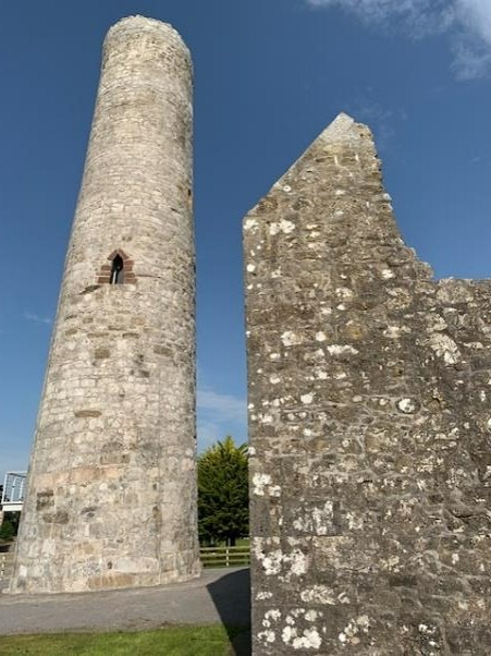
Tory Hill just outside Croom, towards Crecora is said to have been home to the kings of Munster, in 1852 a gold Lunula (2000-500BC) was discovered here and is housed in the National Museum of Ireland. Dysert Aengusa, Croom has the remains of a church and round tower from with the initial buildings dating from 780
The history of Croom as a town begins with the coming of the Normans, when a powerful branch of the Geraldine’s, or Fitzgerald’s, settle in Croom. There were two great branches of the Geraldine’s, the Munster or Desmond Geraldine’s, and the Kildare Geraldine’s. It was the latter who, for a time, had their headquarters in Croom. They owned extensive tracts of land in the Maigue valley, including lands at Croom and Adare, while their Kinsmen, the Munster Geraldine’s, owned the greater part of the rest of Co. Limerick.